
Update August 21, 2017 10:53 am Arizona Time
We all went onto the roof of our building with a pair of NASA safety glasses. My co-worker, David Melville, took the following photo at 10:50 am Arizona Time.
Thanks, David!
Eclipse on August 21, 2017 10:50 am Arizona Time in Glendale, Arizona

Readers:
On August 21, 2017, millions of people across the United States will see nature’s most wondrous spectacle — a total eclipse of the Sun. It is a scene of unimaginable beauty; the Moon completely blocks the Sun, daytime becomes a deep twilight, and the Sun’s corona shimmers in the darkened sky.
GreatAmericanEclipse.com has provided maps and heaps of great information regarding the eclipse.
Their work has received critical notice in many premier news outlets and informational websites. In addition, they can also provide complimentary copies of their two books, See the Great American Eclipse and Atlas of the Great American Eclipse for the purpose of book reviews. Email greatamericaneclipse@gmail.com to request review copies.
The first section showcases eclipses that occurred during the 20th century.
The second section provides context for the total solar eclipse of August 21, 2017.
The third section discussed the solar eclipse that will occur on April 8th, 2024.
Be safe tomorrow. Don’t stare directly into the eclipse or the sun.
Best regards,
Michael
History of Past Eclipses in the 20th Century
The total solar eclipse of June 8, 1918 crossed the United States from Washington State to Florida. This path is roughly similar to the August 21, 2017 total solar eclipse and was the last time totality crossed the nation from the Pacific to the Atlantic.
The US Naval Observatory dispatched an expedition to Baker City, Oregon and successfully observed the eclipse. An artist, Howard Russell Baker, sketched the corona and made a fine painting of the eclipse. Baker City is also within the path of the 2017 eclipse.

The total solar eclipse of September 10, 1923 just grazed the southwestern corner of California, crossing Point Concepcion, the Channel Islands, and San Diego. Bad weather thwarted most observers in this area.

The total solar eclipse of January 24, 1925 was seen by perhaps millions of people in the New York metropolitan area and the northeastern United States. It was a brilliantly clear but very cold day in New York. This eclipse was notable for the number of observatories fortuitously placed in the path as well as the airplanes and dirigible dispatched for a better view.

The total solar eclipse of August 31, 1932 crossed over northeast Canada and the states of Vermont, New Hampshire, Maine, and a small part of Massachusetts. Many people took trains to New England to witness this spectacle.

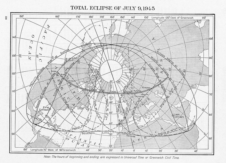
A total solar eclipse crossed over the northwest United States and Canada on July 9, 1945 as the second World War was winding down. Newspapers of the day splashed eclipse news along with news of bombing raids on Japan.
The total solar eclipse of June 30, 1954 began at sunrise in Nebraska and traversed South Dakota, Iowa, Minnesota, and Wisconsin before crossing Canada on its way to Scandinavia, Europe, and South Asia.

The total solar eclipse of October 2, 1959 began over Massachusetts. The late Professor Donald Menzel of Williams College hired an airplane to view the eclipse with some of his students. One student, Jay Pasachoff, went on to become a prominent solar astrophysicist and credits this experience as a defining moment in launching his career studying the Sun’s corona.

The northeast corner of the United States was again visited by the Moon’s shadow on July 20, 1963. This eclipse is a plot device in a novel by Stephen King, Gerald’s Game.

The total solar eclipse of March 7, 1970 crossed the state of Florida and much of the Atlantic seaboard. Many of today’s veteran eclipse chasers began their pursuit with this eclipse as it was accessible to many on the East Coast.

The last total solar eclipse within the contiguous 48 United States was on February 26, 1979. Many of those who traveled to see this eclipse were successful but only because of relocating under partly cloudy skies.

The total solar eclipse of July 11, 1991 was the last to touch any of the 50 United States. Many flew to Hawai’i for this eclipse and sadly most were disappointed by unseasonably cloudy weather on the Kona coast of the Big Island. Many others flew or drove to the tip of Baja California and were rewarded with excellent views of an extremely long duration eclipse, up to 6 minutes and 53 seconds.

August 21, 2017
Overview maps of the 2017 eclipse
The total solar eclipse occurs only within the yellow path as shown in this map. Do whatever it takes to station yourself inside this path, preferably in the middle so that you can enjoy the maximum duration of totality. Furthermore, select your location on the basis of the short-term weather forecast and ensure that you can jump in a car and drive to another location if clouds threaten your location.
Map(s) Credit: Michael Zeiler, GreatAmericanEclipse.com

How to read these eclipse maps
On the map above, the yellow curves parallel to the path of the total solar eclipse mark the degree of maximum partial eclipse. ‘Magnitude’ refers to the maximum fraction of the Sun’s disk occulted by the Moon. The green lines show the times of greatest eclipse as they sweep across the country. The time above the path of totality is given in Universal Time (formerly called Greenwich Mean Time) and time below is given in the local time zone. The orange curves inside the path of the total solar eclipse show the duration of the total solar eclipse. The longest durations of totality are in the middle part of the path.
The map below shows the same phenomena but with more detail.

Additional Maps Related to Tomorrow’s Eclipse


When will the next one be after tomorrow?
Total solar eclipse of April 8, 2024 over Mexico, the United States, and Canada
The next total solar eclipse in the Americas comes on April 8, 2024. Totality first touches Mexico, enters the United States at Texas, cuts a diagonal to Maine, and visits the maritime provinces of Canada.
Although it has been a long 38 years since the last U.S. total solar eclipse before 2017, it is a relatively short 7 years to the succeeding total solar eclipse in North America. Perhaps we should call this the Great North American Eclipse.


One thought on “DataViz as History: Maps Illustrating The Solar Eclipses of the 20th Century”