
Readers:
For those of you who have visited my blog before, you know that I love antique or vintage maps.
I recently perused the Persuasive Maps: PJ Mode Collection at Cornell University Library.
Here are 10 really cool maps I found in the collection related to America.
I hope you enjoy them as much as I do.
Best wishes,
Michael

Collection: Persuasive Maps: PJ Mode Collection
Creator(s): Covarrubias, Miguel
Date: 1943
Subject: Pictorial, World War II, Ethnocentrism
Full Title: Untitled [United States]
Extent: (cm, H x W) 35 x 45 page
Number: 1314.01
Source: Esquire Magazine, January 1943.
Collector’s Notes:
This wonderful pictorial map comes with an explanation by the artist-mapmaker, beginning: “Now in time of war, we are latently awakening to the grandeur, color and infinite variety of this America we fight to defend. . . .” During the period leading up to World War II and through the end of the war, a number of maps celebrated the unity, strength and confidence of the nation. Many of these were published in leading magazines of the time. The collection includes several examples: ID #1275.01-.04, Life Magazine, “America’s Future” (1939); ID #1288, “America – A Nation of One People From Many Countries” (1940); ID #1314, Esquire Magazine, Miguel Covarrubias (1943); ID #2019, “Animated North America” (1944);ID #1332, Holiday Magazine, “William Gropper’s Folklore Map of America” (1946).
For full details on references, see http://persuasivemaps.library.cornell.edu/content/references.
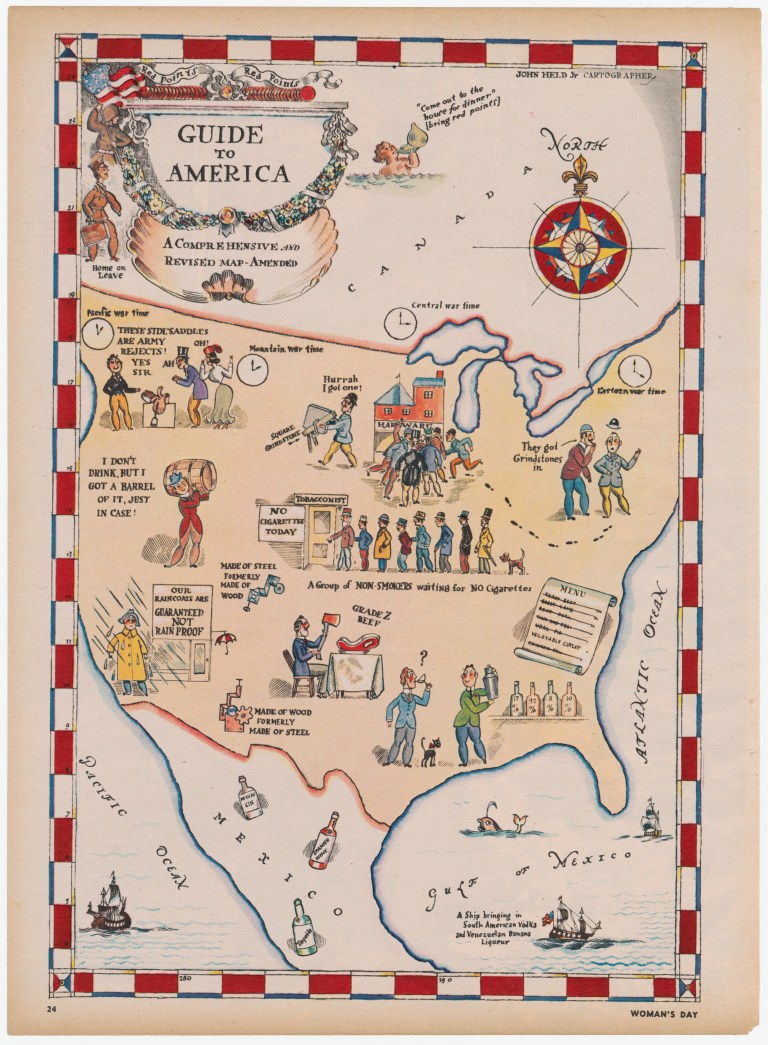
Collection: Persuasive Maps: PJ Mode Collection
Creator(s): Held, John Jr.
Date: 1942
Subject: World War II, Politics & Government, Satirical, Pictorial
Full Title: Guide to America. A Comprehensive and Revised Map – Amended
Extent: (cm, H x W) 26 x 18
Source: Woman’s Day. Date unknown.
Collector’s Notes:
This map by comic artist John Held satirizes the shortages of World War II America. Reference is made to “red points” under the rationing system as well as “Grade Z beef” and vegetable cutlets on the menu. Some of the shortages relate to every day items like alcohol, cigarettes and raincoats, while others are far afield (side saddles; grindstones). It appeared in Woman’s Day magazine. The date is unknown, but was likely in late 1942 after “red points” (for food rationing) had been adopted but while the concept was still new enough to be worth satirizing.
For other satirical maps by John Held, see ID #1234, A Map for the “Scofflaw,” 1931; ID #2072, Map of an Imaginary Estate, 1931.
References:
For full details on references, see http://persuasivemaps.library.cornell.edu/content/references.
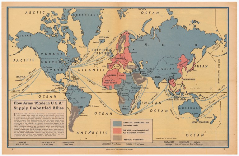
Collection: Persuasive Maps: PJ Mode Collection
Creator(s): Unknown
Date: 1942
Subject: World War II
Full Title: How Arms “Made in U.S.A.” Supply Embattled Allies
Extent: (cm, H x W) 33 x 51
Number: 2263.03
Source: Philadelphia Inquirer, February 13, 1942, pp. 8-9.
Collector’s Notes:
This map is from a War Atlas published by the Philadelphia Inquirer weeks after Pearl Harbor, reflecting and supporting the mood of the country. The territory colored blue (“Anti-Axis Countries and Controlled Land”) overwhelms the pink “Axis-Occupied and Controlled Countries.” The caption asserts that the “United States – Arsenal of Democracy – is shipping the sinews of war, planes, guns, tanks and shells to the fighting democracies in every section of the world, across all the Seven Seas.” In fact, it would be some time before the U.S. built up the domestic industrial production, as well as the anti-submarine warfare capability, to provide the “sinews of war” needed by the allies around the world.
References:
For full details on references, see http://persuasivemaps.library.cornell.edu/content/references.
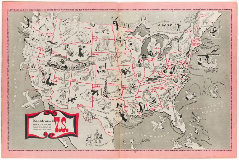
Collection: Persuasive Maps: PJ Mode Collection
Creator(s): Unknown
Date: 1944
Subject: World War II, Pictorial
Full Title: Kaart van de U.S. waarop een deel van den arbeid van de 48 staten in oorlogs en vredestijd is afgebeeldm (A Map of the U.S. Showing Some of the Work of the 48 States in War and Peace)
Extent: (cm, H x W) 35 x 52 (sheet)
ID Number: 1321.01
Source: Kijk Magazine, December 1944
Collector’s Notes:
As allied forces achieved success in the liberation of Europe, the U.S. government worked with publishers and other media entities to produce “consolidation propaganda,” materials to help win the peace (Hench 2010, 69). One of the principal objectives of this effort was “disintoxification,” reorienting the mindset of civilians from years of “an unrelenting onslaught of Nazi censorship and propaganda,” particularly “the highly negative picture of Americans and their culture that Goebbels’s propaganda machine had spread widely.” Another goal was “to explain what the United States had been doing during the War,” since Europeans knew “surprisingly little about the U.S. war effort.” (Ibid).
This map was part of that effort|it is filled with images are of friendly, happy, industrious Americans. Many are shown in the roles they played in winning the war: building aircraft in Washington, tanks in Detroit, ships in California and on the Gulf Coast|military training in Texas, Georgia and North Carolina. Others are shown in their peacetime roles: growing potatoes, timber, tobacco, cattle, sheep, corn and cotton|producing textiles, steel, oil, cheese and movies|racing horses, fishing and skiing.
It was the centerfold in a magazine entitled Kijk (Look) distributed in Belgium in December 1944. A notation in the magazine describes it a “a fortnightly published by the American Information Service. The edition will be discontinued as soon as a need for it no longer exists among the Belgian people.”
References: For full details on references, see http://persuasivemaps.library.cornell.edu/content/references
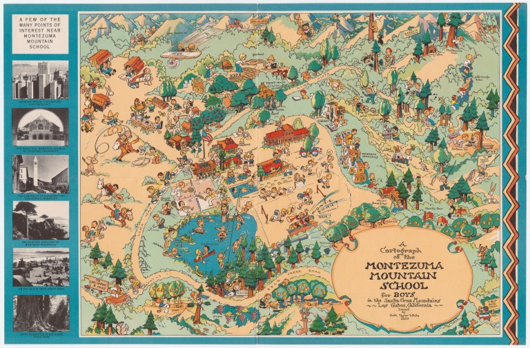
Collection: Persuasive Maps: PJ Mode Collection
Creator(s): White, Ruth Taylor
Date: 1933
Subject: Advertising & Promotion, Pictorial
Full Title: A Cartograph of the Montezuma Mountain School for Boys in the Santa Cruz Mountains, Los Gatos, California
Extent: (cm, H x W) 27 x 35
ID Number: 2134.01
Collector’s Notes:
This is a promotional map for the Montezuma Mountain School for Boys, a prep school “that drew children of the rich and famous to a remote corner of the Santa Cruz Mountains” in northern California from 1910 to 1955. http://www.mercurynews.com/ci_22741079/from-archives-montezuma-mountain-school-boys-rustic-campus, accessed March 15, 2015. The map is dense with pictorial elements showing happy boys engaged in a vast range of activities, with an emphasis on outdoor and athletic events.
The school was founded and run by Professor Ernest Rogers, “an educational pioneer” whose “avant-guarde theories” included rigorous chores for the 150 students, the study of Esperanto, and extensive “legislative-style debates” in a student government organization he also founded, the Junior Statesmen of America. Ibid. The campus, on 264 acres above what we now call Silicon Valley, included a fishing pond, dairy, horses, orchard and cannery. In the 1930s, when this map was made, the school excelled both academically and in sports. Ibid.
The core of the school’s campus is now a conference and retreat center operated by The Sisters of the Presentation.
References:
For full details on references, see http://persuasivemaps.library.cornell.edu/content/references.
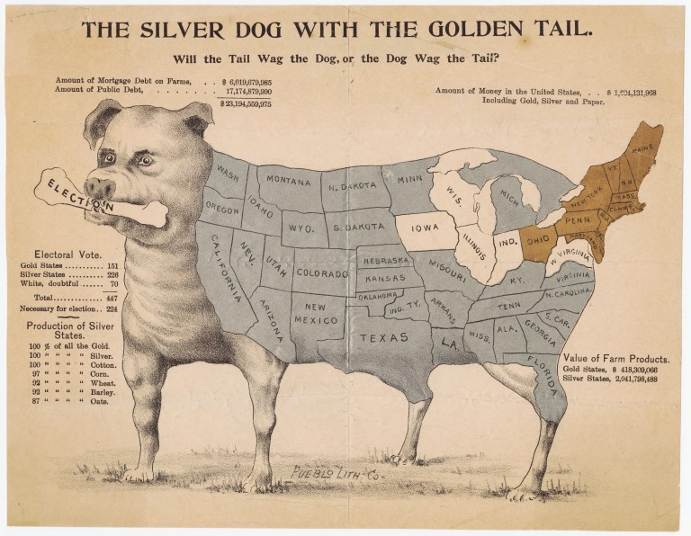
Collection: Persuasive Maps: PJ Mode Collection
Creator(s): Unknown
Date: 1896
Subject: Politics & Government, Satirical, Pictorial, Unusual Graphics/Text
Full Title: The Silver Dog With the Golden Tail. Will the Tail Wag the Dog, or the Dog Wag the Tail?
Other Creator(s): Peublo Lith. Co.
Extent: (cm, H x W) 20 x 26
ID Number: 2053.01
Collector’s Notes:
This flyer supports the position of the populist Democratic candidate William Jennings Bryan on the critical issue in the 1896 Presidential race, “Free Silver.”
Bryan proposed a return to the free coinage of silver at a fixed ratio of 16 to 1 with gold, although the market ratio was in fact some 30 to 1. While few voters at the time (as now) understood the complex workings of bimetallism, both sides agreed that the Free Silver proposal would result in substantial inflation. Bryan and his supporters embraced such a consequence as a remedy for the Panic of 1893, a severe depression that had created high unemployment, falling prices and severe pressure on farmers. Free Silver would allow beleaguered farmers and others to repay debts with inflated dollars. Bryan’s famous acceptance speech at the Democratic convention concluded by warning opponents: “You shall not press down upon the brow of labor this crown of thorns; you shall not crucify mankind upon a cross of gold.” The Republican candidate, William McKinley, opposed Free Silver for precisely the reason Bryan supported it, arguing that a dollar would be worth just 47 cents and economic chaos would ensue. Supported by eastern business and financial interests, he characterized the election as “a struggle to preserve the financial honor of the government,” urging voters to support “an honest dollar” and “an untarnished national credit.”
This flyer superimposes an outline map of the states on a fierce dog with an “Election” bone in its mouth. The southern and western farm states Bryan hoped to win are overlaid in silver. The industrial northeastern states likely to support McKinley are overlaid in gold, and five “doubtful” states are left white. An “Electoral Vote” count shows that the “Silver States” alone would give Bryan the Presidency, assuring viewers that the Silver Dog would Wag the Golden Tail. In the end, McKinley won not only all of the “Gold” and “doubtful” states, but California, Kentucky, Michigan, Minnesota, North Dakota and Oregon, giving him an overwhelming electoral college majority (along with a 51% to 47% popular vote victory). Free Silver had less traction four years later in the 1900 Presidential election because the economy was in recovery, and McKinley defeated Bryan by a larger margin, only to be assassinated the following year. The United States remained on the gold standard until the 1970s, at which point it had become essentially irrelevant as a result of post-war international economic developments.
The first version of this map appeared in the Boston Globe of September 13, 1896, and was quickly reproduced across the country. An article about the election results in The Review of Reviews reproduced the picture and called it, “A campaign poster much used in the west.” ID #2055.01, “The Silver Dog With the Golden Tail” – And the Tail Wagged the Dog After All. The broadside here is unusual because it is not only in color, but features the gold and silver metallic overlays. I have found reports of only one other copy, this one with an added legend: “Compliments of Nuckolls Packing Co., Pueblo, Colorado.” Lane 2001, 80.
“This humorous map was created by supporters of the silver currency to make fun of the gold states and reinforce the community of the silver states. The map . . . portrayed an image of isolation of the ‘golden states’ associated with wealth (gold), by dissociating them from the body of the country/dog and associating them with the tail of the animal. . . . implicitly [arguing] . . . in favor of marginalizing the East Coast. Here, humor and maps are combined to generate a propagandist perspective of the U.S. nation-state, challenging the image of a country historically dominated by the wealthy East Coast elite. This humorous map was not sufficient to reverse this tendency or to impede the emergence of the gold standard. It contributed, nevertheless, in reversing the image of a nation dominated by the Northeast.” Caquard 2008, 56.
For persuasive maps concerning Bryan’s presidential run in 1908, see ID ##2279.01-.02, “The Map of Bryanism” (1908) and ID #2282, “That Diminishing Blot on the Elephant” (1907).
References:
For full details on references, see http://persuasivemaps.library.cornell.edu/content/references.
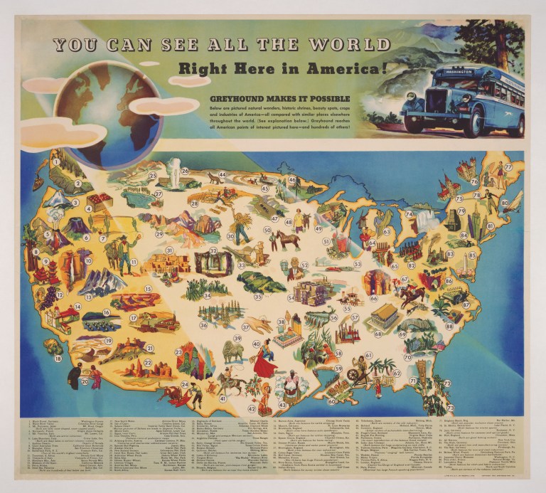
Collection: Persuasive Maps: PJ Mode Collection
Creator(s): Greyhound Corporation
Date: 1935
Subject: Advertising & Promotion, Pictorial
Full Title: You Can See All the World Right Here in America! Greyhound Makes It Possible
Extent: (cm, H x W) 32 x 60
ID Number: 1272.01
Source: Published by Greyhound Management Company
Collector’s Notes:
In the depths of the Depression, Greyhound offered travel to “natural wonders, historic shrines, beauty spots, crops and industries of America – all compared with similar places elsewhere throughout the world.” For each of 88 numbered foreign sites one might want to visit, Greyhound offers an American alternative: Holland/Holland Michigan Tulip Farms|Shanghai/San Francisco Chinatown|Nile Valley/Texas Cotton Fields|Parthenon, Greece/Parthenon, Nashville. Date is estimated.
References:
For full details on references, see http://persuasivemaps.library.cornell.edu/content/references.

Collection: Persuasive Maps: PJ Mode Collection
Creator(s): Nitsche, Erik
Date: 1939
Subject: Between the Wars, Pictorial, Ethnocentrism
Full Title: Portrait of America 1939
Extent: (cm, H x W) 36 x 53
ID Number: 1275.01
Source: Life Magazine, June 5, 1939, pp. 52-53.
Collector’s Notes:
In the summer of 1939, following the German annexation of Czechoslovakia, the threat of war hung over Europe. Henry Luce, the publisher of Time, Life and Fortune magazines, was the most powerful American media figure of his era, and his concern about American isolationism and our lack of military preparedness were reflected in his publications. Baughman 2001, 2-3, 120. Life Magazine dedicated its issue of June 5 to “America’s Future.” The issue included an essay by Walter Lippman on “America’s Destiny,” and a section on “America in Maps” with four powerful, double page illustrations (ID ##1275.01-.04). The overall impact communicates an upbeat view of the nation and its prospects.
During the period leading up to World War II and through the end of the war, a number of maps celebrated the unity, strength and confidence of the nation. Many of these were published in leading magazines of the time. The collection includes several examples: ID #1275.01-.04, Life Magazine, “America’s Future” (1939); ID #1288, “America – A Nation of One People From Many Countries” (1940); ID #1314, Esquire Magazine, Miguel Covarrubias (1943); ID #2019, “Animated North America” (1944);ID #1332, Holiday Magazine, “William Gropper’s Folklore Map of America” (1946).
References:
For full details on references, see http://persuasivemaps.library.cornell.edu/content/references.
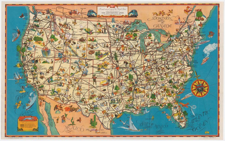
Collection: Persuasive Maps: PJ Mode Collection
Creator(s): Pacific Greyhound Lines
Date: 1935
Subject: Advertising & Promotion, Pictorial
Full Title: A Good-Natured Map of the United States setting forth the services of The Greyhound Lines and a few principal connecting bus lines
Extent: (cm, H x W) 29 x 47
ID Number: 2070.01
Collector’s Notes:
Greyhound produced a great number of these pictorial promotional maps in the 1930s. Because of the depression, this period was the high water mark of long-distance bus travel in the U.S. For an unusual version suggesting an alternative American destination for those interested in a number of exotic foreign locations, see ID #1272, “You Can See All the World Right Here in America! Greyhound Makes It Possible.” Date is estimated.
References:
For full details on references, see http://persuasivemaps.library.cornell.edu/content/references.
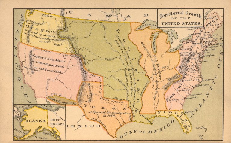
Collection: Persuasive Maps: PJ Mode Collection
Creator(s): Unknown
Date: 1881
Subject: Imperialism
Full Title: Territorial Growth of the United States
Extent: (cm, H x W) 10 x 16
ID Number: 1083.01
Source: Anderson, John J. 1881. A Junior Class History of the United States. New York: Clark & Maynard, Publishers. P. 226.
Collector’s Notes:
This map showing the “Territorial Growth of the United States” was typical of the period. From the middle of the 19th century, through the fervor of the Spanish-American War, and until the first stirring of World War in Europe, territorial expansion was one of the defining themes of America. The notion of “manifest destiny” supported the acquisition of territory, first across the continent, and then abroad. Maps reflecting and reinforcing those views were “standard fare” in American textbooks, atlases and other works. Schulten 2012, 58, 187-88. The collection includes a number of examples: ID #2075 (1875); ID #1083 (1881); ID #1090 (1884); ID #2062 (1898); ID #2106.01 (1906); ID #2110 (1907); ID ##2196.01-.02 (1915). This map is from a textbook “designed . . . for elementary classes.”
References:
For full details on references, see http://persuasivemaps.library.cornell.edu/content/references.
