Readers:
![]() I recently discovered 1843 Magazine. 1843magazine.com is the website of 1843, the culture, lifestyle and ideas magazine from The Economist. It offers content from the print edition, as well as The Daily, which regularly publishes blog posts – quickfire observations, reviews and opinions. Access is entirely free via the Apple iOS devices and Android devices.
I recently discovered 1843 Magazine. 1843magazine.com is the website of 1843, the culture, lifestyle and ideas magazine from The Economist. It offers content from the print edition, as well as The Daily, which regularly publishes blog posts – quickfire observations, reviews and opinions. Access is entirely free via the Apple iOS devices and Android devices.
1843 is published six times a year.
Apple iOS users can download here.
Android users can download here.
I hope you enjoy this example of data visualization as a map from Adam Green.
Best regards,
Michael
Europe on the Brink
This article was originally published by Adam Green. Mr. Green is editor-in-chief of the Public Domain Review, an online journal dedicated to the exploration of curious works from the history of art, literature, and ideas.
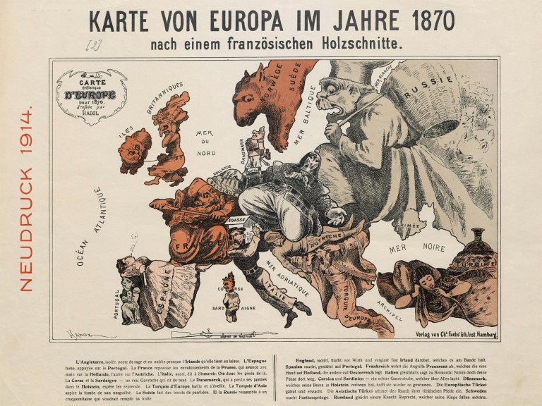
This satirical map from 1870 shows a Europe in crisis, bristling with tensions which would, come July that year, erupt into the Franco-Prussian war. The conflict’s political fall-out – French humiliation at the loss of Alsace-Lorraine and British fears about a now unified and much more powerful Germany – would play a major role in the outbreak of world war one more than 40 years later. For all its serious subject matter the map manages to lend a little humour to the affair, with each nation anthropomorphised as a comical caricature. Prussia is depicted as the enormous walrus-like figure of the “Iron Chancellor” himself, Otto von Bismarck. France, kitted out as a Zouave soldier from French north Africa, is seen heroically repelling the Prussian sprawl (it is worth pointing out that the map was first published in France).
Pictured as an old woman, Britain is “isolated and fuming with rage”, turning away decidedly from events on the mainland, almost forgetting, as the caption tells us, about Ireland, the rather cute dog she keeps on a leash. The degrees of longitude are marked out in rifle lengths, a nice touch alluding to the explosiveness of the situation. The map is the work of French illustrator and caricaturist Paul Hadol (1835-1875), who on occasion also went by the rather enigmatic pseudonym of “White”. Although caricature maps existed in Europe from the 14th century, this is one of the first in which the forms of the countries themselves were rendered accurately as actual characters, a style that was to be repeated throughout the rest of the 19th century and on into the 20th. Indeed, this version of the 1870 map shown here is actually a German reprinting from 1914, which seems to have been produced to accompany a new anthropomorphised map of Europe illustrating the tensions preceding world war one.
Source: Adam Green, Europe on the brink: An isolationist Britain turns her back on a continent descending into chaos, 1843 Magazine, March 15, 2016, https://www.1843magazine.com/ideas/the-daily/europe-on-the-brink.
Photo: Staatsbibliothek zu Berlin

One thought on “Dataviz as Maps: Europe on the Brink”